
AtoZ Bucket List
"Where have you been?"


AZ Places
This directory is a history of places we have personally traveled for camping and exploring throughout Arizona, Utah and New Mexico and beyond. Places from the Forests to Deserts with Lakes, Rivers, Hot Springs, Caves and Peaks. Historical and Abandoned places, Ghost Towns and Ancient Runes. Recreation Areas and National & State Parks. Enjoy!

Abandoned
Ancient Ruins
Caves
Desert
Forest
Ghost Towns
Historical
Hot Springs
Lakes
National & State Parks
Peaks
Rivers
Chevelon Canyon Lake
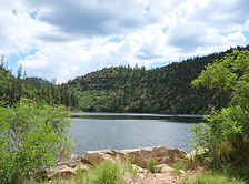

Arizona
Coconino County
Chevelon Canyon Lake, Apache-Sitgreaves National Forest, AZ, USA
34°30'33.3"N 110°50'27.3"W
Chevelon Canyon Lake, nestled on the Mogollon Rim in northern Arizona, is a serene, hidden gem offering fishing, hiking, and camping. Accessible via a challenging hike, this narrow reservoir is surrounded by rugged canyon views, perfect for nature lovers seeking adventure.
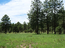
Coconino National Forest: Happy Jack
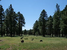

Arizona
Coconino County
MJ2G+RHM Lost Eden, Arizona
34°39'07.6"N 111°22'24.9"W
Happy Jack, located in the Mogollon Rim Ranger District of the Coconino National Forest, offers a peaceful escape for dispersed camping. With its cooler summer temperatures, towering pines, and diverse wildlife, it’s a perfect destination for outdoor exploration and relaxation.
Colossal Cave Mountain Park
Arizona
Pima County
16721 East Old Spanish Trail, Vail, AZ 85641
32°03'44.7"N 110°38'03.1"W
Colossal Cave Mountain Park has cave tours, hiking & biking, trail rides, camping & picnicking, terrace Café & gift shop. The campsites are tucked among the saguaro cacti and mesquite trees in Posta Quemada canyon. These grounds consist of two large areas, El Bosquecito and La Selvilla, both have water and restrooms. Additionally there are a number of smaller areas totaling 30 individual sites. Camping is first-come, first-served. This is primitive camping. No electricity or RV hook-ups available. are located in El Bosquecito and La Selvilla.
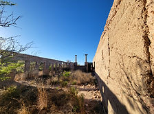
Courtland Ghost Town


Arizona
Cochise County
N Pearce Rd, Elfrida, AZ 85610
31°46'13.2"N 109°48'31.9"W
Nestled in an arid landscape, Courtland, born from early 1900s mining fervor, whispers tales of a once-thriving community. A fading jail, a collapsing store, and silent foundations stand as echoes of its past. The hills, marked by mines, caution visitors of the hidden hazards within the remnants of Courtland's mining legacy.
Gleeson Ghost Town
Arizona
Cochise County
Gleeson, AZ
31°43'59.0"N 109°49'47.3"W
Gleeson explorers can discover the remains of a school, a restored jail, hospital, a saloon, a cemetery, and indications of the significant mining activities in the nearby hills. The Gleeson cemetery is situated to the west of the town along the road leading to Tombstone.
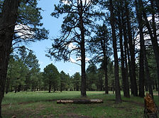
Heber-Overgaard FR 124
Arizona
Navajo County
8HV6+VMJ Heber-Overgaard, Arizona, USA
34°20'43.5"N 110°26'15.6"W
Discover the beauty of Arizona along Forest Road 124 in the Apache-Sitgreaves National Forest. This scenic destination features rugged forest terrain, towering ponderosa pines, and open meadows dotted with vibrant wild mushrooms. Visitors can also witness burn scars from the historic Rodeo-Chediski Fire, now blending with vibrant new growth—a powerful testament to nature's resilience. Wildlife you may encounter include wild horses, jackrabbits, deer, foxes, and squirrels.
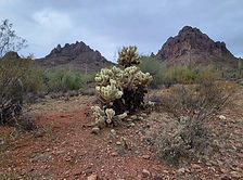
Ironwood Forest National Monument
Arizona
Pima County
Ironwood Forest National Monument, Marana, AZ 85653, United States
32°28'02.8"N 111°28'29.6"W
Ironwood Forest National Monument is a protected area located in southern Arizona, United States. It was established in 2000 and covers approximately 129,000 acres of Sonoran Desert landscape. The monument is named after the iconic ironwood trees (Olneya tesota) that grow within its boundaries.
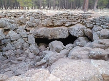
Lava River Cave
Arizona
Coconino County
171b Forest Rd, Flagstaff, AZ 86001
35°20'32.2"N 111°50'08.2"W
This mile-long lava tube cave was formed roughly 700,000 years ago by molten rock that erupted from a volcanic vent in nearby Hart Prairie. The top, sides and bottom of the flow cooled and solidified first, after which the insides of the lava river continued to flow emptying out the present cave.
McFadden Peak
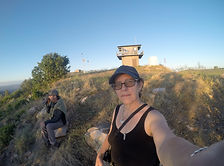
Arizona
Gila County
McFadden Peak, Arizona, USA
W26M+2J Aztec Lodge, Arizona
McFadden Peak, the site of one of two fire lookouts in the Sierra Ancha, offers continuous views of the surrounding areas. This peak was named for William McFadden, who started the Circle Ranch on McFadden Creek. McFadden had been part of a vigilante group during the Pleasant Valley War, and later settled in the Sierra Anchas to get away from the feud.
Meadow Hot Springs
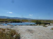
Utah
Millard County
Meadow Hot Spring, Utah
38°51'52.2"N 112°30'11.6"W
Located just 4 miles south of Fillmore, Utah is the quiet little town of Meadow. Meadow Hot Spring is located just west of the town of Meadow, in an open field. The spring is located on private property, but the land owner has continued to make it accessible to the public. The property has been improved with fences and a nicely graded walking path that connects three different pools. The property owners have posted several signs at the main gate so please respect their wishes and obey the posted rules, this will ensure that this beautiful natural resource will remain open to the public.
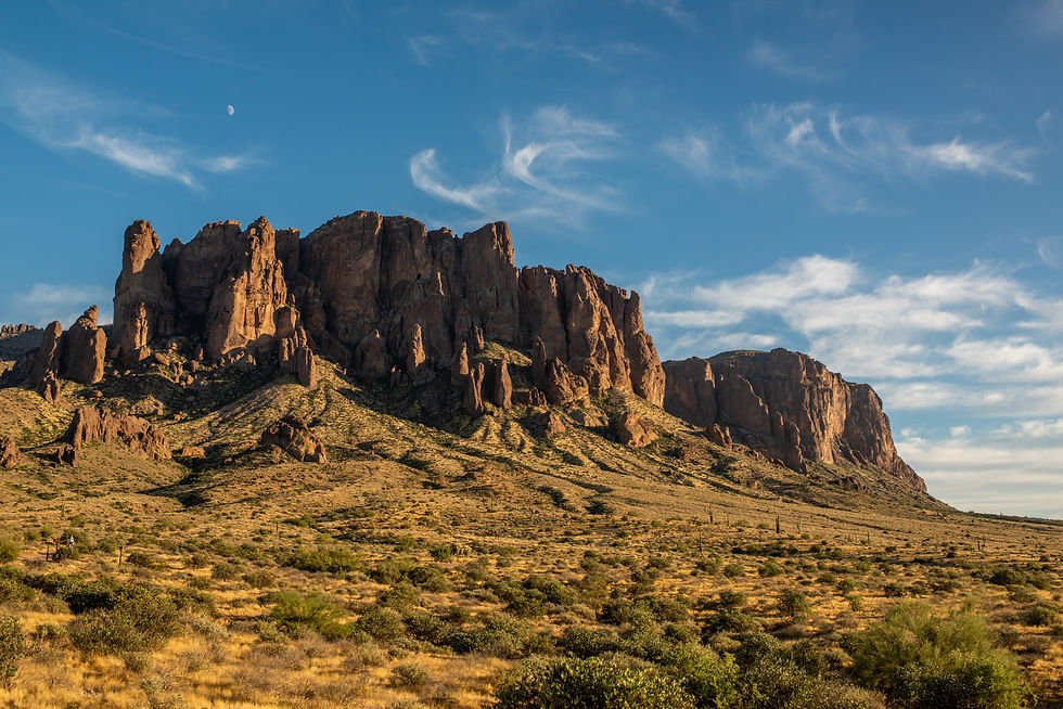
Organ Pipe Cactus National Monument
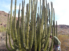
Arizona
Pima County
Organ Pipe Dr, Ajo, AZ 85321
31°57'17.0"N 112°48'05.0"W
Explore the rugged beauty of Organ Pipe Cactus National Monument, a UNESCO biosphere reserve where vast desert landscapes meet striking mountain ranges. Discover rare flora, hike scenic trails, and experience the vibrant biodiversity of Arizona’s Sonoran Desert.

Arizona
Abandoned
Ancient Ruins
Caves
Desert
Forest
Ghost Towns
Historical
Hot Springs
Lakes
National & State Parks
Peaks
Rivers